Understanding flood damage on a 3D diorama Up-frontier
Up-frontier has released the app “Diorama Vision – Flood Map” that allows users to see flood damage on a 3D diorama. The flood map will raise disaster prevention awareness and support local governments nationwide in creating safe and secure cities that are resilient to disasters.
NTT QONOQ will also sell the app as a package with the MagicLeap 2, which is compatible with this app, so that users can use it immediately after a simple application.
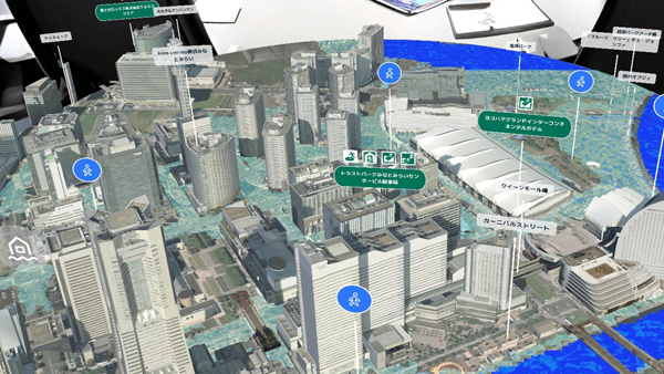
This app allows users to see the state of a city where flood damage has occurred from a bird’s-eye view.
The city is displayed as a 3D diorama instead of a flat map, and the areas that will be flooded are covered with water. By viewing the flood damage from above, users can intuitively see which areas are dangerous. Information on evacuation shelters is also displayed, so users can see at a glance where to evacuate when flood damage occurs.
Up to four types of flood damage can be displayed: high tide, tsunami, inland water, and flood. The flooding status of the city can be checked for each flood damage. It is also possible to display flood damage in different colors according to water depth, allowing users to judge the depth of the water by its color.
※Translating Japanese articles into English with AI