Advancing disaster prevention information collection NTT DATA
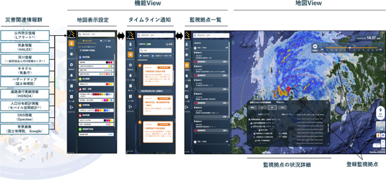
NTT DATA has added ”base monitoring function”, ”email notification function”, and ”Google map as background map” as new functions to ”D-Resilio Viewer”.
In addition, “River Water Level Information” (provided by the River Information Center, General Incorporated Foundation) and “Hazard Map” (provided by the Ministry of Land, Infrastructure, Transport and Tourism Hazard Map Portal Site) have been added as new content to the collaboration platform “D-Resilio Collaboration Platform.”
D-Resilio Viewer’s new site monitoring function allows you to register points where you want to quickly grasp the local situation, such as sales offices, factories and other facilities, and raw material suppliers scattered throughout the country. If there is a change in the vicinity of each registered base, in addition to notifications on the timeline, it also has a function to send an email.
With the new content of the D-Resilio collaboration platform, local governments and companies that use it can use river water level information to obtain the risk of flooding in nearby rivers in advance, and use hazard maps to check the potential risks of their bases. By doing so, you can consider safety measures and evacuation actions for your base in advance.
D-Resilio Viewer is a web viewer that allows you to use the contents of the “D-Resilio Collaboration Platform” without requiring individual system support or complicated applications.
The D-Resilio collaboration platform is a platform that enables governments and companies to efficiently collect disaster prevention information and supports consideration and decision-making of proactive disaster response measures in the event of a disaster that requires a quick and accurate response.