High-precision, long-distance 3D surveying with a smartphone OPTiM
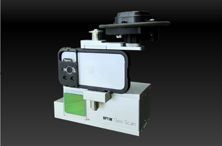
OPTiM released a terrestrial laser scanner “OPTiM Geo Scan Advance” that enables high-precision, long-distance 3D surveying with a smartphone on Wednesday, 24th. As a commemoration of the release, the dedicated hardware will be sold at a limited price of 333,000 yen (excluding tax) for one year.
Generally, terrestrial laser scanners on the market cost about 8 million to 10 million yen. OPTiM Geo Scan Advance, on the other hand, is characterized by its low price of 333,000 yen.
In addition, there is no troublesome preparation or specialized operation, so it is easy to introduce. For example, since it is equipped with a tilt detection device (IMU), there is no need for specialized operations such as leveling when surveying.
Since it is linked with a GNSS receiver, there is no need to bring in surveying equipment and conduct surveys for preparation in advance, such as positioning work that was previously required.
As a terrestrial laser scanner using a GNSS receiver, OPTiM Geo Scan Advance complies with the Ministry of Land, Infrastructure, Transport and Tourism’s “manufacturing management guidelines using three-dimensional measurement technology.”
LiDAR sensors built into iPhones and iPads have a range of up to five meters, making surveying difficult in some cases. For example, on a slope with a height, it was necessary to survey while walking on the slope. In addition, there are also voices that want to use 3D surveying for surveying disaster sites such as landslides that are difficult to approach, and for surveying and inspecting tall structures such as bridges, steel towers, and utility poles.
Therefore, by connecting an external LiDAR sensor with a long scanning distance to the iPhone, we made it possible to easily perform long-distance surveying.